Early hiking season in South Senja
If you are keen to start the hiking season without the need for skis or snowshoes, then South Senja is the place to explore first.
Family-friendly hike on flat ground
Dronningsruta (The Queen’s Route) from Hofsøy to Stangnes (Ryvoll)
The snow on the ground on the northern coast of Senja can melt several weeks earlier compared to the southern coast.
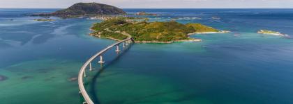
Dronningruta (The Queen’s Route) from Hofsøy to Stangnes via Stongodden runs almost completely on the seashore most of the way, making it one of the first hikes you can take in the springtime with dry feet. Most people choose to park their car at Midt-Troms Museum in Hofsøy and then set off on foot along the tractor road which leads onto a path near the sea further towards Ryvoll. The is an easy walk with small coastal rocks, beaches and flat terrain virtually all the way. Consequently, this route is suitable for people of all ages.
There are beautiful views along the route towards islands such as Andørja, Grytøya and Hinnøya. You have the option of returning to Hofsøy from Ryvoll along the path that goes further inland near the headland. Although you may encounter some wet bog in places, the path leads past several of the famous low coastal pine protected in the nature reserve. The hiking route is approx. 8 km one way, slightly shorter if you walk back on the path.
If you only want to walk in one direction, it’s possible to park one car at each end of the route.
Popular peaks early in the season
Strytind
Strytind is a popular peak in the mountains between the Veidmannsfjord and Grunnfarnes in Søndre Torsken.
The starting point for this hike is at the end of the road to Kalfarnes. From there, a well-marked path leads west along the seashore for about 1 km. When the path turns towards the northwest, it marks the start of the climb up the ridge to the summit as well as the halfway point of the hike up. If you go do this hike on a fine evening, you will get the evening sun all the way up from here. Spring starts early here and by Easter most of the path is already free of snow.
Consequently, this is one of my top five summit hikes in early spring. From the top, you look straight down on Grunnfarnes and the mountains Dalfjellet and Høgtinden which tower above the village. If you look towards Medby, you will see the Veidmannsfjord and the Sifjord, which is the next fjord past the mountain Veidmannsfjellet. Looking westwards, you will spot Andøya and Andenes. The views from the summit are spectacular even though this mountain peak is only 413 m above sea level. If you look northwards, the chances are good that you will see the Midnight Sun.
This hike suits most people and is not especially demanding. The distance from the starting point to the summit is barely 2.5 km.
Sjursviktinden
The mountain peak Sjursviktinden is situated in Sjursvika, which is just past the village of Skrolsvik in South Senja.
It’s easy to find the starting point, which is virtually at the end of the road. A reasonably well-marked and signposted path starting by the parking bay on the left-hand side of the road. Sjursviktinden is one of my favourites because the snow near the summit melts so early. I would classify this peak (837 m above sea level) as moderate to demanding. The route begins gently before the steepest ascent starts. Some people find the summit a bit exposed, but it’s more exciting than frightening.
The path is well-marked all the way, apart from up to the last section which is scree. The hike to the summit is approx. 3 km and takes an average person just over an hour. From the top, you will be rewarded with views of the rest of the village Senjahesten and the mountain peaks Buviktinden and Lonketinden. The pinnacle peaks also make Flakstadvåg and Kvænan easy to recognise. If you look westwards, which is where you came from, you can see the islands of Sandsøya, Bjarkøya, Flatøya and Meløyvær.
On fine days, the views from the summit are impeccable and are wonderful to experience in the Midnight Sun.
Høgtinden and (Lille) Breitinden
Climbing to the summit of Høgtinden in Medby is an easy and manageable hike for most people. Don’t confuse this hike with Høgtinden in Grunnfarnes.
Although the snow remains on the ground here a few weeks longer than Strytinden, this still becomes a hiking shoe-friendly route relatively early. It may be a good idea to bring snowshoes early in the season. The starting point is from Ungdomshuset (the youth hall) located at the entrance to the village of Medby. If you look up to the right as soon as you drive into the village, you will see the peak that has a book at the summit you can sign. The hiking route starts from the waterworks. You start by following a steep tractor road up to lake Rødbergvatnet, from where a marked path leads all the way to the top.
The summit is 402 m above sea level, making this hike manageable for most people. If you travelled a long way and think the hike is a bit short, you can extend your hike by continuing up to the trip up to (Lille) Breitinden (662 m above sea level). Breitinden is the top of the ridge behind you when you are standing at the top of Høgtinden and looking down towards Medby. From Høgtinden, you look straight down into the Veidmannsfjord. If you continue up to Breitinden, you can also enjoy the view in the other direction of the Osterfjord and the village of Torsken, among other places.
On sunny and clear days, continuing to Breitinden is well worth the effort because the view is beautiful.
Lonketinden
Lonketinden (848 m above sea level) is one of the highest peaks in South Senja and is one of my favourite mountain climbs in Senja in summer and winter alike.
This mountain offers a fantastic 360° panoramic view. The starting point for this hiking trip is the Finnelva river, which you will spot just after driving through the village with the distinctive Norwegian name of Å. From there, a gravel forest road leads a few hundred metres up to a small dam and a shed where it’s possible to park. A marked path leads from here up to the summit. In early spring, I usually treat this as a combination of two-thirds snowshoeing and one-third hiking. You normally need snowshoes on the first section up to Lonketuva, from where the long ridge leads up towards the top of Lonketinden. The ground here is bare early, so you can often switch from snowshoes to hiking shoes.
There are generally a few snow cornices left on the summit, so you will probably need to switch back to your snowshoes for the final approach. If you choose this hike, you will be rewarded with wonderful views. When you reach Lonketuva, you can turn around and admire the view of the island of Lemmingsvær and catch a glimpse of the islands of Sandsøya and Andørja in the distance. From the summit, you will have a view that stretches as far as the eye can see. The altitude enables you to catch a glimpse of most of the high peaks in Senja. The summit is a popular trip destination for outdoor enthusiasts year-round and depending on the season can be reached by skis, snowshoes or hiking shoes. My personal preference is the spring and summer. The path is very easy to follow during the summertime, but some of the mashes may be wet so remember to wear waterproof hiking shoes or boots.
This is a demanding hike that requires some hiking experience but the view from the summit makes it worth trying.


 Contact us